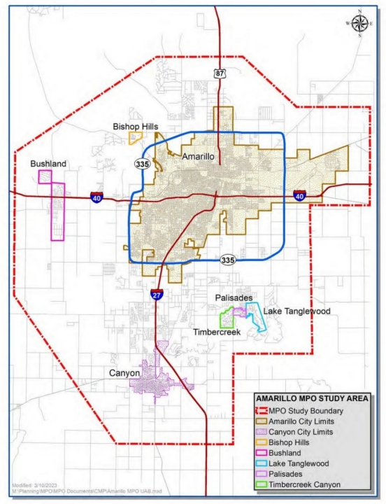
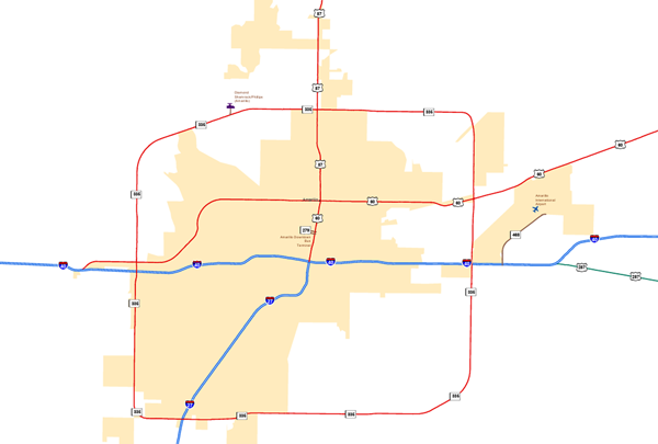
The Amarillo MPO collaborates with local, county, and state officials to coordinate and develop transportation systems, ensuring effective planning, coordination of transportation modes, and proposing projects that meet the region’s transportation needs.

Metropolitan Planning Organization Maps​

Amarillo Metropolitan Planning Organization Study Area Map

Metropolitan Area Boundary Map

The MPO’s study area, known as the Metropolitan Area Boundary (MAB), includes Amarillo, Canyon, Bushland, and several surrounding communities.


Federal Highway Administration (FHWA)

The Federal Highway Administration (FHWA) provides stewardship over the construction, maintenance and preservation of the Nation’s highways, bridges and tunnels.

TxDOT Statewide Planning

The Amarillo Metropolitan Planning Organization Policy Committee meets quarterly in January, April, July, and October. Click here to find information about past and upcoming meeting agendas and minutes.

Bike Routes

Explore Amarillo’s bike routes and access maps for local cycling paths.

Loop 335 Project Map​

TxDOT, in consultation with the Amarillo MPO and regional stakeholders, has initiated action to begin the realignment of the southwest portion of State Loop 335 to the Helium Rd corridor. This is a multiphase project. Click here to access our interactive map for the 335 Corridor.

COA City Construction Projects Map

City Construction Projects

The Amarillo City Construction
Projects Dashboard offers real-time updates on infrastructure projects including roadwork, utility, water, drainage, and wastewater.

Amarillo City Transit Map Image

Amarillo City Transit System Map

Explore the Amarillo Transit System Map to view bus routes, service areas, and timepoints throughout the city.

City of Amarillo's Planning Department Interactive Map

City of Amarillo's Planning Department Interactive Map

The City of Amarillo’s Planning Department Interactive Map is a public tool offering zoning, land use, and development details, including layers for neighborhoods, flood zones, schools, utilities, and more.
City of Canyon Interactive Mapping

City of Canyon Interactive Mapping

The City of Canyon’s mapping application provides access to geographic data and mapping capabilities. The mapping application contains a wealth of information regarding the City of Canyon.


Select A Language to Translate This Page

About Translations on Amarillo.gov

The City of Amarillo offers translations of content on Amarillo.gov through the Google Translate web translator (translate.google.com). Because Google Translate is an external service, the City does not control the quality or accuracy of translated content. As a result, some translations may contain inaccuracies, and there may be issues with the appearance of translated pages, including errors in images.

If you encounter incorrect or substandard translations, you can help improve them by contributing better translations using Google Translate:

  1. Hover over any text containing an error, and a pop-up box will appear.
  2. Click “Contribute a better translation.”
  3. Double-click the area of the pop-up that says “Click a word for alternative translations, or double-click to edit directly.”
  4. Make your edits directly in the text box.
  5. Press “Contribute” to submit your suggested changes.

For more information on contributing to Google Translate, visit Google Translate’s help page.

Please note that the City of Amarillo does not control the process by which contributed translations are incorporated into Google Translate.

The City of Amarillo is dedicated to enhancing the accessibility and multilingual content available on our website.